General Information
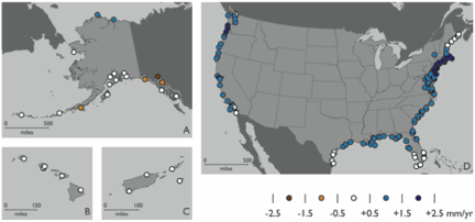
Map depicting contribution of GIA to net changes in RSL varies for much of the US coastline Alaska (A), Hawaii (B), Puerto Rico and the US Virgin Islands (C), and the contiguous US (D), as predicted by the ICE-5G(VM2) model (Peltier 2004). Rate locations are tide gauge sites in the Permanent Service for Mean Sea Level (PSMSL) dataset. Values account for sharp coastal gradients through use of a high spatial resolution model, and represent rates averaged over the 20th and 21st centuries. For US territories not shown, rates fall within the -0.5 to +0.5 mm/yr range.
Data Type:
Simulated
Variable Type:
Sea
Region:
Files